 Index
Index

Nebraska is located in the center of the United States, almost equidistant from the Atlantic and Pacific oceans. But during the Cretaceous Period, ninety million years ago, most of Nebraska was at the bottom of the Western Interior Seaway that separated North America into Laramidia (west) and Appalachia (east). Then, during the Paleocene Epoch, fifty five million years ago, the Laramide orogeny that started forming the Rocky Mountains lifted central Nebraska approximately 700 meters above sea level and drained the Western Interior Seaway.

The Rainwater Basin Wetland Complex
South-central Nebraska is dominated by a large plain of
fluvial sands and gravels deposited on the southern side of the Platte River.
These older deposits are covered by a few meters of loess (wind-blown dust).
The Rainwater Basin area spans 21 counties and nearly 6,200 square miles. Rainwater and snowmelt fill the basins every year, making it ideal for migratory waterfowl looking for food, roosting and shelter between their southern wintering retreats and northern nesting grounds. The seeds and tubers from wetland plants, and corn from surrounding farms, are rich resources for birds looking for mates on their way to their final destination. When the shallow basins warm in late spring, they provide a habitat for insects and aquatic invertebrates.

The wildlife in Central Nebraska in early spring is absolutely spectacular. As winter draws to a close in late February or early March, millions of birds that include Sandhill Cranes, five geese species and several duck species converge on the central Platte River valley and Rainwater Basin Wetland Complex. Peak migration is during the latter half of March, but weather conditions can affect arrival and departure of large numbers of birds. Mallards and Northern Pintails are two abundant early arrivals. Male mallards have a green head. Northern Pintails have brown heads with white neck feathers.

The Rainwater Basin Wetland Complex is located within both the tall and mixed grass ecosystems. Flora and fauna that historically existed in the area were the result of natural ecological processes such as wildfire, grazing, drought, and flooding. Agricultural development at the beginning of the twentieth century started converting the large, flat wetlands for crop production by digging ditches to drain the land, building dikes or berms around wetlands, digging deep pits to concentrate the water, and diverting runoff toward streams.
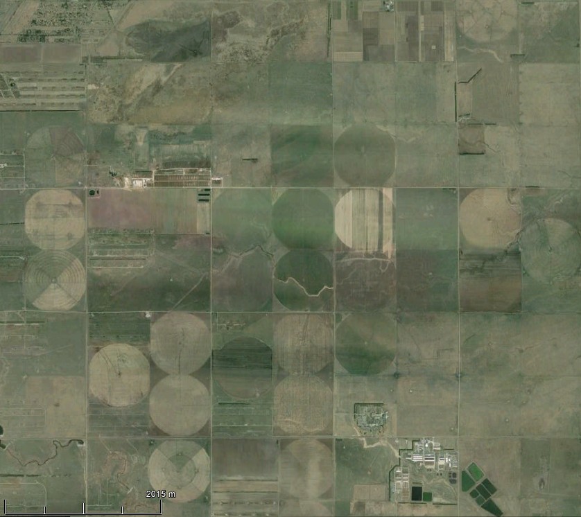
Nebraska is known as the "cornhusker" state because it produces a lot of corn. The circles in the image above have a diameter of half a mile, and they are made by quarter-mile long center pivot irrigation systems like the one illustrated below.


The Nebraska Rainwater Basins
The image above shows the same farmland as the previous image but viewed
with LiDAR, which displays the surface elevation with a gradation of colors.
The image is from high-resolution 2-meter Ground Sample Distance (GSD) LiDAR data
with 0.39 meter vertical accuracy which was released in 2010 by
the Nebraska Department of Natural Resources.
The square farm parcels can still be distinguished, but large elliptical
structures with raised rims can also be seen.
These large elliptical structures are the Nebraska Rainwater Basins.
In 1994, Mark Kuzila conducted a subsurface investigation to determine the morphology of two basins in Clay County, Nebraska. Transects were located across two sample areas, and seventeen test holes were drilled to determine loess thickness and stratigraphy. Radiocarbon dates were obtained from buried paleosols. The modern basin landscape was determined to be a direct result of 2.5 to 8 meters of loess deposition on an older basin landscape. The modern landscape generally mirrors the paleolandscape except that the modern basin ridges seem to have less relief than the paleoridges. The paleobasins were formed prior to the Early Wisconsinan deposition of the Gilman Canyon Formation. Kuzila concluded that it is likely that other large basins within the eastern rainbasin are underlain by paleobasins and are the result of prior basin-forming processes.
In 2001, William Zanner and Mark Kuzila proposed a relationship between the Nebraska Rainwater Basins and the Carolina Bays. Zanner and Kuzila first noticed a multitude of oval shaped features that share SW-NE orientation south of the Platte River in east central Nebraska using USGS Digital Orthophoto Quadrangles (DOQs), which are computer-generated images of aerial photographs in which the image displacement caused by terrain relief and camera tilt has been removed. The DOQ combines the image characteristics of the original photograph with the georeferenced qualities of a map. The oval features occur in a variety of sizes and have rims on the southeast edge. Locally they are called Rainwater Basins. Prior work of Kuzila suggested that the Nebraska Basins exist where a loess dated at ~27,000 radiocarbon years before present provides a pre-existing topography. Soil survey maps of the area show that some rims of the Basins are sandy. Cores from the area indicate that a sandy landscape was buried by loess. Upper parts of these sandy deposits are well sorted; fluvial sands and gravels occur below these sorted sands.
Zanner and Kuzila concluded that the Basins on the current land surface originally formed as blowouts or low spots in abandoned Platte River fluvial sands and gravels where the long axis of the basin is perpendicular to regional prevailing wind directions. Loess later draped a pre-existing topography formed in these sands. Zanner and Kuzila postulate that the Nebraska Rainwater Basins would be recognized as an analog of the Carolina Bays if not for their loess cover, and that any explanation for the existence of the Carolina Bays should also help explain Nebraska's Rainwater Basins.

Geometrical Analysis
In 2015, Zamora published a geometrical analysis of the Carolina Bays and
the Nebraska Rainwater basins showing that both of these geomorphological
features have width-to-length ratios of 0.58 ± 0.05 and that the bays
with well defined borders can be precisely fitted with ellipses.
The width-to-length ratio of the bays corresponds to conic sections inclined
at 35 degrees.
The Carolina Bays and the Nebraska Rainwater Basins are radially
oriented toward Saginaw Bay in Michigan (Davias and Harris, 2015),
so it is reasonable to propose that glacier ice ejected in ballistic
trajectories by an extraterrestrial impact on the Laurentide ice sheet
could have formed these structures as explained in the book:
Solving the Mystery of the Carolina Bays.

References: