Meteor Crater, also known as Barringer Crater, is a meteorite impact crater located near Flagstaff, Arizona. It is the most thoroughly investigated and one of the least eroded impact craters in the world.
Transcript:
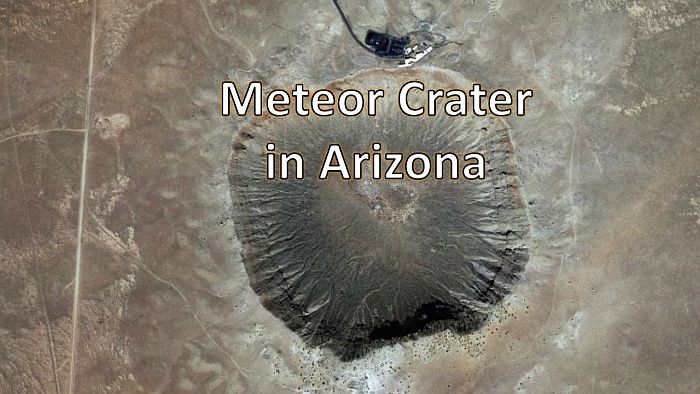
Meteor Crater, also known as Barringer Crater, is a meteorite impact crater located about 60 km or 37 miles east of Flagstaff, Arizona. It has a diameter of about 1.2 kilometers and a depth of 180 meters. The crater was created about 50,000 years ago during the Pleistocene epoch.
In 1903, mining engineer and businessman Daniel M. Barringer suggested that the crater had been produced by the impact of a large iron meteorite, and Barringer's company, the Standard Iron Company, staked a mining claim to the land. Barringer and his partner, mathematician and physicist Benjamin Chew Tilghman, documented evidence for the impact theory in 1906 and published in the Proceedings of the Academy of Natural Sciences in Philadelphia. Barringer's arguments were met with skepticism because there was great reluctance at the time to consider the role of meteorites in terrestrial geology.
In the 1960's, geologist Eugene Shoemaker studied Meteor Crater and compared it with the craters made by nuclear bomb explosions. He found that the high pressures of an extraterrestrial impact produced minerals with planar deformation features. This provided the first conclusive evidence that Meteor Crater was an impact crater. Eugene Shoemaker was an eloquent science communicator and he had many notable achievements, including the co-discovery of the Shoemaker-Levy 9 comet that impacted Jupiter in 1994.
Shoemaker wrote a field guide to Meteor Crater in 1987 that summarized the characteristics of the crater and the conditions of its formation. The guide starts by giving the location of Meteor Crater with directions on how to drive there, and obtain permission in order to hike to various parts of the crater.
Meteor Crater was the first recognized impact crater on Earth; it remains the largest known crater with associated meteorites. It is the most thoroughly investigated and one of the least eroded and best exposed impact craters in the world. Study of Meteor Crater provided clues for the recognition of impact craters on other solid bodies in the solar system, as well as on Earth, and stimulated the search for other terrestrial impact structures.
Meteor Crater is a bowl-shaped depression 180 meters deep and about 1.2 kilometers in diameter encompassed by a ridge or rim that rises 30 to 60 meters above the surrounding plain. The rim is underlain by a complex sequence of Quaternary debris and alluvium resting on deformed and uplifted strata. The debris units on the crater rim consist of angular fragments ranging from splinters less than one micron in size to blocks up to 30 meters long. Because of the striking lithologic contrast between the formations from which the debris is derived, it is easy to distinguish and map units or layers in the debris by the lithic composition and stratigraphic source of the component fragments.
The guide by Shoemaker provides a geologic map of Meteor Crater with a detailed description of the terrain features in and around the crater, including the inverted stratigraphy along the rim.
Shoemaker writes that most of the major structural features of Meteor Crater are reproduced in the Teapot Ess crater in the alluvium of Yucca Flat, Nevada, which was formed by the underground explosion of a 1.2-kiloton nuclear device in 1955. He describes the mechanism of crater formation as follows: In the case of impact, a strong shock races ahead of the projectile into the target rocks, and another engulfs the projectile. At projectile speeds corresponding to encounter speeds of asteroids with the Earth, which are typically in the range 9 to 19 miles per second or 15 to 30 kilometers per second, initial shock pressures generally exceed the dynamic yield strengths of rocks and meteorites by several orders of magnitude. The target rocks engulfed by shock are initially accelerated more or less radially away from the penetration path of the projectile. An expanding cavity is formed by the divergent flow of the target material. Near the cavity wall, the direction of flow is approximately tangent to the wall, owing to upward acceleration in an expanding rarefaction between the shock front and the wall. Part of the target rock and much of the projectile flow up the wall and out of the growing cavity.
As the shock wave expands, pressures at the shock front drop rapidly. A limit for displacement of the target rocks is reached where the stresses in the shock wave drop below the dynamic yield strength of the rocks. This limit defines the outer boundary of deformation and uplift of bedrock beneath the crater rim. The position of the final wall of a structurally simple crater like Meteor Crater or Teapot Ess is located approximately where the outward flow along the wall of the growing cavity is stopped by the combined effects of gravity and the shear strength of the target material. At Meteor Crater, a sheath of fragmented rock that stopped flowing up the cavity wall collapsed back toward the center of the crater to form the thick breccia lens beneath the crater floor.
The kinetic energy of the projectile required to form a crater the size of Meteor Crater can be estimated from computer simulation of the impact process to be about 15 megatons TNT equivalent. This energy is equal to that of a spherical body of meteoritic iron about 130 feet or 40 meters in diameter traveling at a speed of 12 miles per second or 20 kilometers per second, which is the root-mean-square encounter speed of Earth-crossing asteroids. Somewhat greater energy was required if the projectile struck at an oblique angle, as suggested by the presence of faults with underthrust displacement on the north and west walls of Meteor Crater.
Although Meteor Crater is large, it is much smaller than many Carolina Bays. The major axis of some large Carolina Bays exceed 4 kilometers, and Meteor Crater looks very small in comparison.
One feature that is unique to the Carolina Bays is their elliptical geomorphology. Well preserved Carolina Bays can be precisely fitted with ellipses that have the same width-to-length ratios as the bays. Ellipses are conic sections, and this implies that the Carolina Bays originated as inclined conical cavities and were later remodeled into shallow elliptical bays by viscous relaxation.
Experiments demonstrate that oblique impacts on a viscous surface create inclined conical cavities or penetration funnels that look elliptical when viewed from above. The elliptical cavity formed by an oblique impact is surrounded by a raised rim that is formed by overturned flaps typical of impact craters. The penetration of the projectile into the medium produces horizontal compressive forces and ejects debris ballistically to create the stratigraphically uplifted rims.
If we model a large bay based on the proportion of projectile size to cavity size of the experimental impacts, we can estimate that a large bay with a major axis of four kilometers could have been made by an ice boulder with a diameter of 650 meters. From the width-to-length ratio of the bay and its distance from the convergence point by the Great Lakes, we calculate that an ice projectile of that size impacting at an angle of 30 degrees and a speed of 3.5 km/s would have a kinetic energy corresponding to 210 megatons of TNT. This is about 14 times the energy of the impact that made Meteor Crater in Arizona.
The Carolina Bays are the most prevalent geological structures of the Atlantic Coastal Plain. LiDAR images show that all the ground is completely covered by Carolina Bays, except where water erosion has carved fluvial channels. The Carolina Bays most likely originated from secondary impacts of ice boulders ejected by an extraterrestrial impact on the Laurentide Ice Sheet. The saturation bombardment of the ejecta curtain would have killed all the fauna from the Rocky Mountains to the East Coast of the United States. The extraterrestrial impact would have also triggered the Younger Dryas cooling which lasted for 1300 years and caused the extinction of the North American megafauna that survived the initial impact.
If anybody tells you that the Carolina Bays were created by wind and water mechanisms, do not let them hoodwink you. Ask them: How do wind and water create mathematically elliptical features in Nebraska and in the East Coast whose major axes converge by the Great Lakes? If they answer that in 1977 Kaczorowski demonstrated the formation of elliptical features in his sand table experiments, you will need to correct them because this is false.
Kaczorowski only produced a structure similar to a bloated American football with pointy ends, which does not have the smooth geometrical characteristics of an ellipse. Bloated footballs are not elliptical. Science cannot make progress and our knowledge of the Carolina Bays cannot advance if we continue to believe deficient explanations, which do not even consider the Nebraska Rainwater Basins that have the same elliptical geometry as the Carolina Bays.
