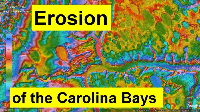
The Carolina Bays are shallow elliptical basins with raised rims that are generally found on unconsolidated soil. The bays are disappearing rapidly because the soil on which the bays are found is easily disturbed by water erosion and human urbanization.
LiDAR is a laser ranging technology that has revolutionized the study of the Carolina Bays. The colorized topography of these images is provided by the LiDAR Visualization Tool for Google Earth by Michael Davias.
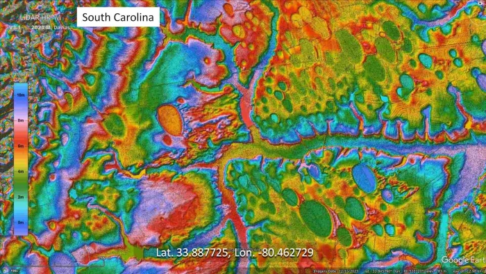
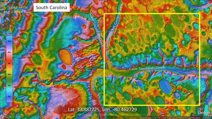
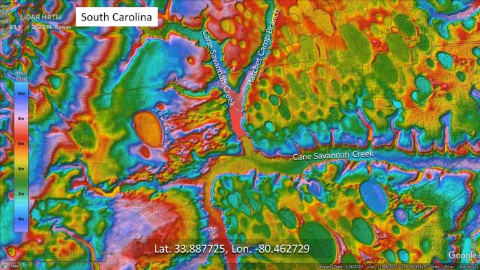
This particular landscape is located about 7 miles west of Sumter, South Carolina. One of the main features of this image is the Cane Savannah Creek that flows from the north and then turns sharply eastward.
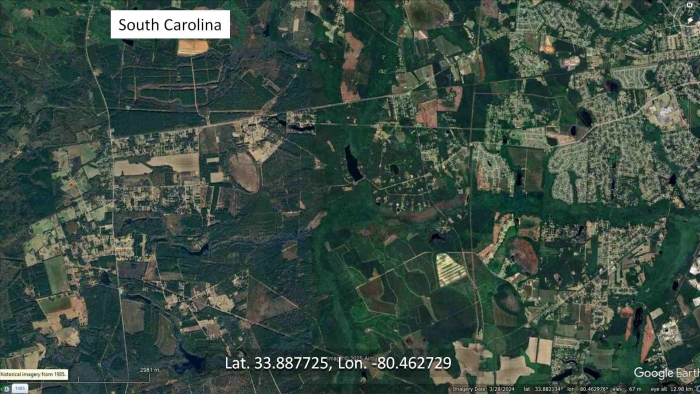
Without LiDAR we would only see a few Carolina Bays and a patchwork of fields crisscrossed by a network of roads. In aerial or satellite images, the subtle geological features of the ground are obscured by vegetation and man-made structures.
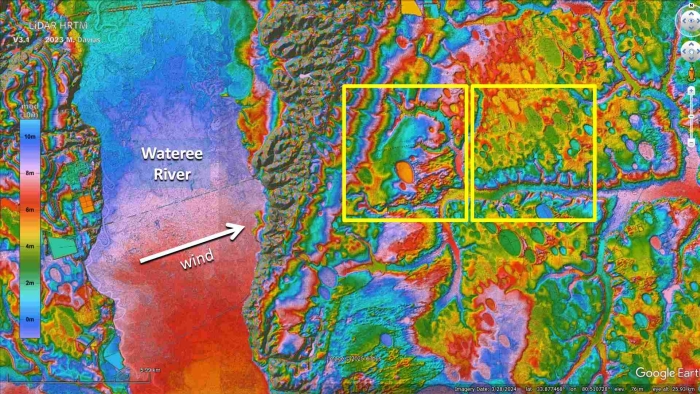
The left side of the image has just a few Carolina Bays. The large basin in the center of the highlighted section measures one kilometer in length, and there are some well-defined wind-blown sand sheets originating from the basin.
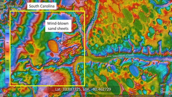
The right side of the image is completely different. The terrain has a high density of Carolina Bays. How can we explain the physical mechanisms that created these contrasting landscapes in such close proximity?
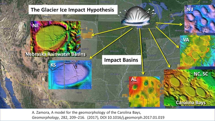
The Glacier Ice Impact Hypothesis, published in 2017, proposes that one or more extraterrestrial impacts on the Laurentide Ice Sheet by the Great Lakes ejected pieces of ice in ballistic trajectories. The secondary impacts produced seismic vibrations that liquefied unconsolidated soil, and the oblique impacts of glacier ice created inclined conical cavities that became shallow elliptical basins by viscous relaxation. In Nebraska, these basins are called Rainwater Basins, and along the Atlantic Coastal Plain they are called Carolina Bays. Some geologists argue that the Carolina Bays are the result of ice melt processes like thermokarst, but North and South Carolina never had permafrost even during the Last Glacial Maximum.
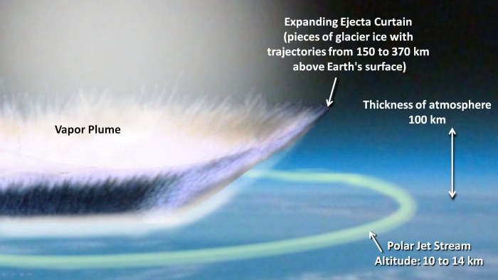
The extraterrestrial impact on the Laurentide Ice Sheet launched pieces of glacier ice in suborbital trajectories with heights of 150 to 370 kilometers above the surface of the Earth. The expansion of the vapor plume produced by the high heat of the impact increased the speed of the ejecta and broadened the shape of the conical ejecta curtain. The expansion of the vapor plume shifted the Polar jet stream southward from the impact point and trapped it under the expanding ejecta curtain. The hurricane force winds of the jet stream were brought to the surface from the normal altitude of 10 to 14 kilometers.
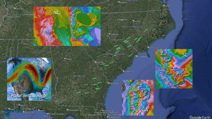
When we plot the direction of the wind-blown sand sheets in the LiDAR images, a pattern emerges along Georgia, South Carolina and North Carolina that closely matches the pattern of the polar jet stream. The strong winds associated with the emplacement of the Carolina Bays indicate that the jet stream was brought down to the surface during the massive ballistic sedimentation of ice boulders that produced the Carolina Bays. The secondary impacts liquefied the soil, and the strong winds in combination with the water from the rivers and lakes created kilometer-long eolian sand sheets. The strong winds only lasted briefly as the Earth's atmosphere reacted to the expanding ejecta curtain and the large amount of material cast out by the extraterrestrial impact. There are many examples of Carolina Bays overlaying the eolian sand sheets and of sand sheets overlaying Carolina Bays. This indicates that the strong winds and the emplacement of the Carolina Bays happened at the same time.
To understand the mechanism that created the terrain near Sumter, South Carolina, we have to zoom out and take a broader perspective. The highlighted features are located to the East of the Wateree River. The arrow indicates the direction of the wind that created the sand sheets associated with the large basin. We can expect that all the terrain in this image was equally bombarded with ice boulders, including the river bed.
The water and mud splashed by the glacier ice bombardment in the Wateree River was carried by the hurricane force winds, and a massive wave of water scrubbed away the bays that had formed in the terrain to the west side of the Cane Savannah Creek.
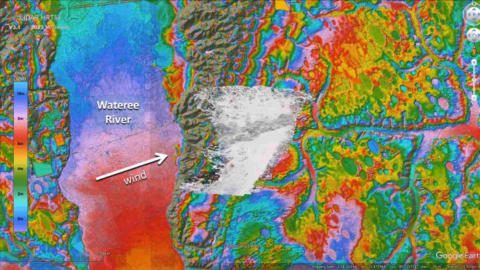
The wind continued blowing while the ice projectiles were falling, but the creek bed was a barrier that directed the water toward the eastward channel.
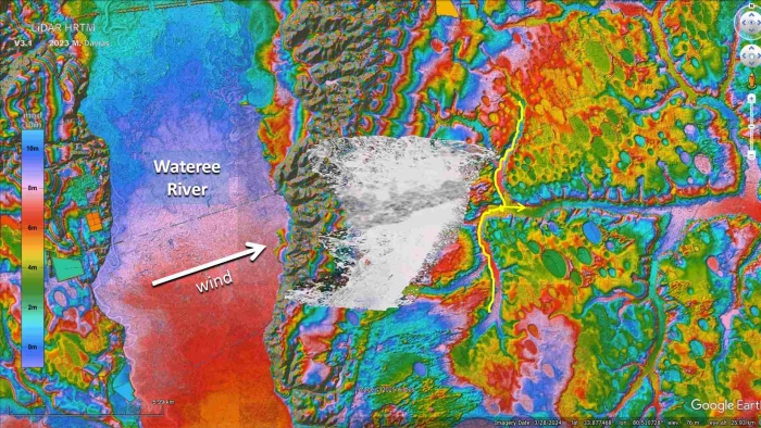
The impacts that created the large bays highlighted in this image occurred after the water that had flooded the area had been diverted to the eastbound Cane Savannah Creek. The strong wind was still blowing and produced the sand sheets associated with the basins. The large amount of water overflowed the eastward channel and eroded some of the bays that had formed adjacent to the creek.
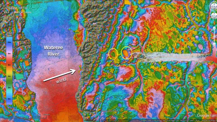
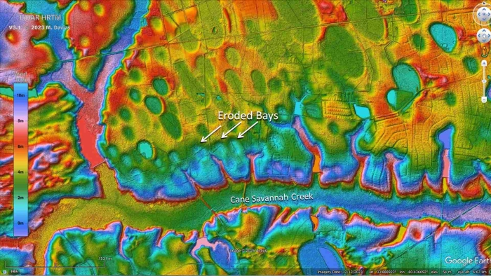
This image shows the Carolina Bays that were eroded along the banks of the Cane Savannah Creek. This erosion happened when the water in the creek was about half a mile wide. The source of the water that eroded these basins was blown by hurricane-force winds from the Wateree River during the horrific ballistic sedimentation of the ejecta curtain of ice boulders that took place from 6 to 9 minutes after the extraterrestrial impact on the Laurentide Ice sheet.
There are many examples proving that strong winds were associated with the emplacement of the Carolina Bays. On the east side of the Lynches River, 14 kilometers southwest from Hartsville, South Carolina there are several well-defined chevron sand sheets, some of which overlay Carolina Bays, and some of which are neatly cropped by the bays. This is evidence that the emplacement of the Carolina Bays was contemporaneous with the emplacement of the sand sheets.
Big Bay is another example of demonstrating that strong winds of short duration were contemporaneous with the emplacement of the Carolina Bays.
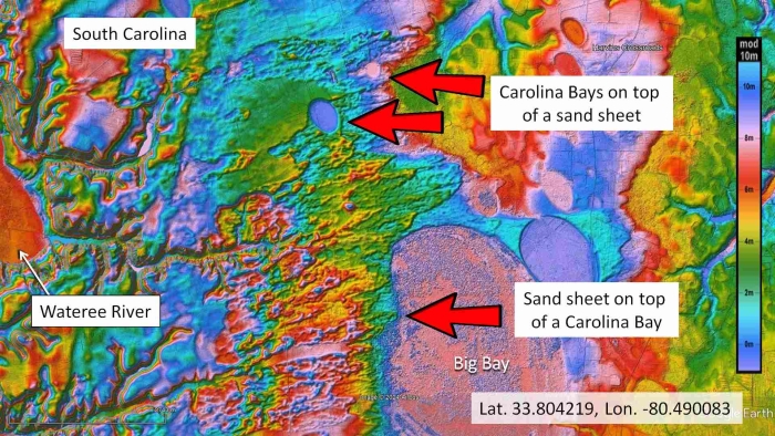
A large Carolina Bay, called Big Bay, is located five kilometers north of Pinewood, South Carolina. The western part of Big Bay is covered by an extensive sand sheet with many pointy chevrons, and the sand sheet itself is overlaid by well-defined Carolina Bays. The sand forming the sheet was dredged by the wind from the east bank of the Wateree River, which is about 7 kilometers west from Big Bay.
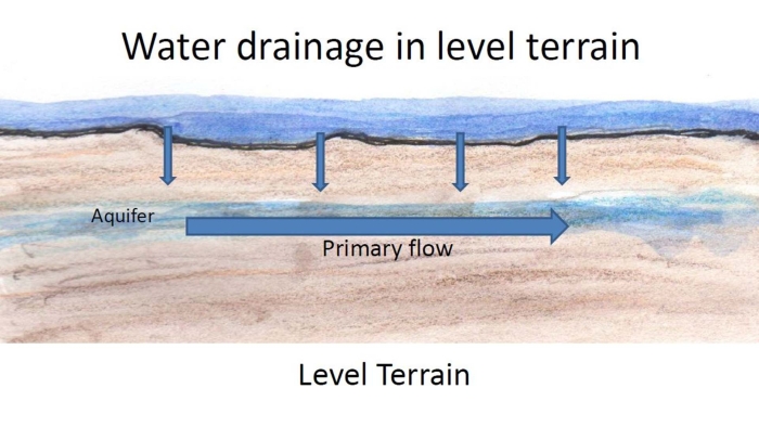
The preservation of the Carolina Bays can be explained by the way in which water drains. In level terrain, rain water cannot flow fast horizontally along the surface, so it percolates through the soil and then flows toward lower terrain via underground aquifers that eventually lead to the ocean. The slow horizontal flow of water on the surface reduces erosion of the Carolina Bay features, especially if the terrain has grasses or other vegetation that stabilizes the soil.
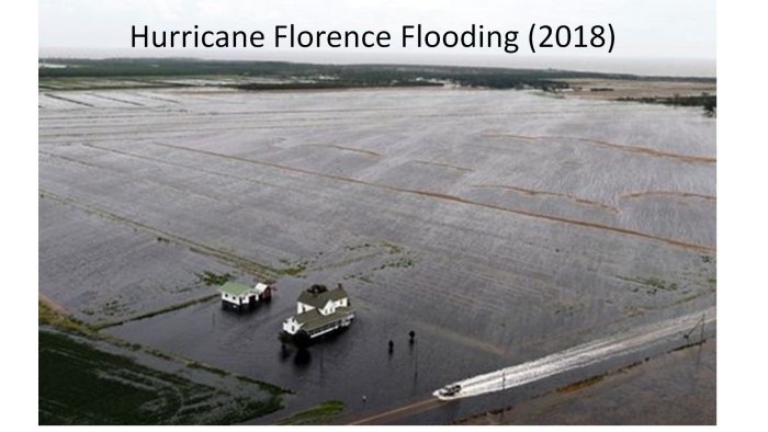
This image shows the flatness of the terrain in the Coastal Plain. Hurricane Florence brought heavy rains to North Carolina in 2018 and caused extensive flooding. The terrain is fairly level, so water flows very slowly along the surface, which minimizes erosion of the Carolina Bays. The water eventually percolates through the ground and is carried toward the ocean by underground aquifers that connect to the streams and rivers. The level terrain and the porous ground have contributed to the preservation of the Carolina Bays for approximately thirteen thousand years, but deforestation, agriculture and urbanization have made the terrain less resistant to water erosion.
The National Oceanic and Atmospheric Administration keeps historical hurricane tracking data. This image shows the paths of hurricanes in North America during more than 150 years.
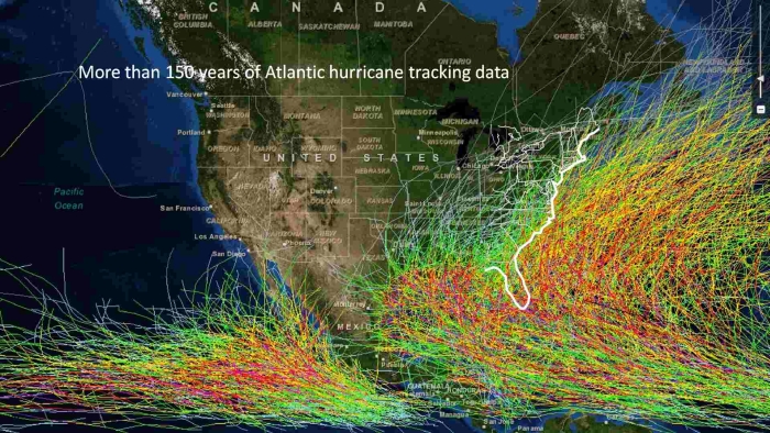
The United States is constantly battered by hurricanes. As indicated here, Florida, Georgia and the Carolinas show the largest concentration of hurricane landfalls along the Atlantic coast. Even if only two hurricanes per year made landfall in the Atlantic seashore, in a period of 12,000 years there would be a total of 24,000 hurricanes, many of which could have produced storm surges capable of destroying Carolina Bays in terrain below four meters above sea level.
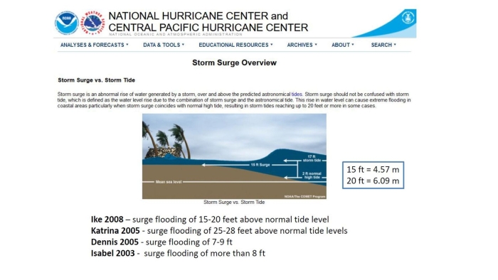
The National Hurricane Center says that when a storm surge coincides with a normal high tide, the resulting storm tide can be twenty feet or higher. Carolina Bays in terraces at 4 meters of elevation can be flooded easily by the storms that frequently batter the Atlantic Coast. The temporary rise in sea level due to storms and high tides is sufficient to erase all traces of Carolina Bays in low lying areas over a period of time. Storm surges accompanied by high winds can stir up sand and erase all traces of the Carolina Bays.
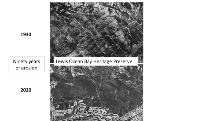
These are images of the Lewis Ocean Bay Heritage Preserve near Myrtle Beach, South Carolina, which was established in 1988. The terrain is approximately 12 to 15 meters above sea level. In the 1800s, the area was used for logging and turpentine production, and during World War II, a portion of the area was a gunnery range. The upper image, taken in 1930, shows some well-defined Carolina Bays in the middle of the picture. Many of those bays are completely gone in the bottom picture after ninety years without substantial human activity. The disappearance of the bays is mostly due to erosion by rain.
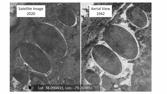
This is another example of 78 years of erosion. The terrain is in South Carolina at about 11 to 12 meters above sea level and 35 miles from the Atlantic Ocean. Little by little, the features of the bays are washed away by rain until the bays finally disappear. Each drop of rain may move just a few grains of sand, but the results are significant after many years.
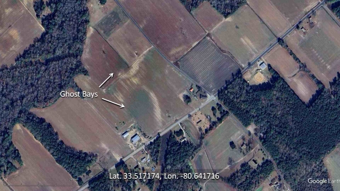
The term "Ghost Bays" was used by geologist William Prouty to describe Carolina Bays that are in the process of disappearing by water erosion. The presence of ghost bays is suggested by a curved outline of white sand surrounding a region of darker soil.
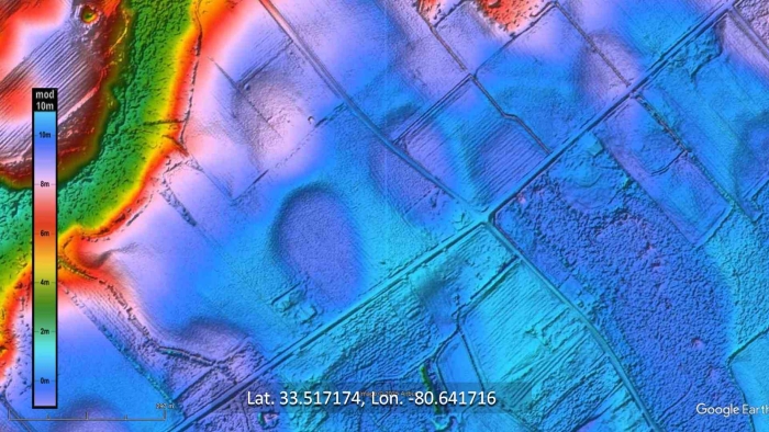
The use of LiDAR reveals the slight differences in elevation between the center of the ghost bays and their rims. Usually the rims are less than one meter higher than the centers of the basins.
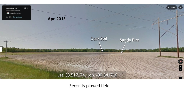
This Google Street View image from April of 2013 shows the dark soil in the center of the ghost bay and the white sandy rim.
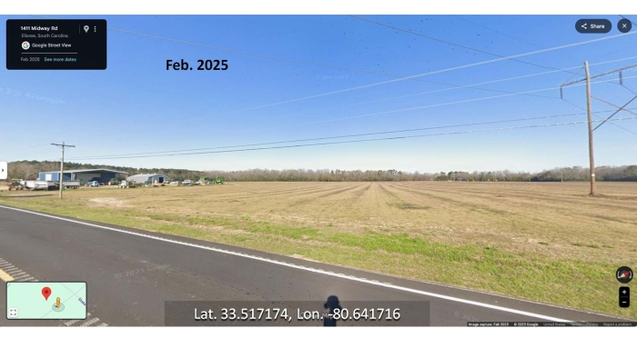
The street view from February of 2025 shows an empty field, but the dark soil in the center of the ghost bay cannot be seen. Twelve years of tilling the field for crops have changed the characteristics of the surface of the terrain, but LiDAR is still able to detect the slight changes in elevation between the centers and the rims of the bays.
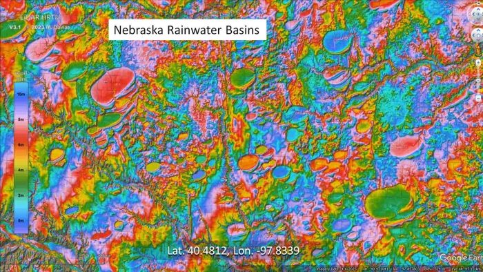
Elliptical basins analogous to the Carolina Bays are found on the unconsolidated soil south of the Platte River in Nebraska. It is difficult to find basins smaller than 4 kilometers in this area because most of them have been completely eroded on the inclined irregular terrain.
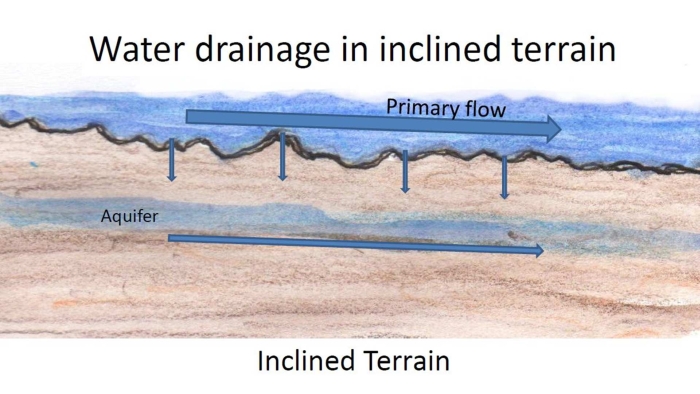
On inclined terrain, rain water flows downhill, but some water also passes through the soil to underground aquifers. The flow of water along the surface is turbulent and erodes the sandy soil, eventually erasing the features of the Carolina Bays and Nebraska Rainwater Basins.
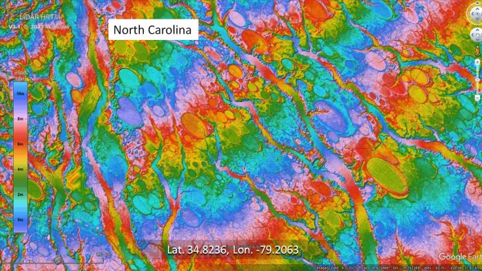
Water erosion is the greatest destroyer of these fragile sandy structures. This LiDAR image shows many bays whose rims have been breached by water drainage channels. We have to wonder how long these elliptical features have withstood the erosive action of rain and how much longer they will last. Judging from the rapid deterioration of the bays during the last century we have to conclude that the Carolina Bays are relatively recent geological structures and that they will probably be completely gone in a few thousand years. Dust to dust. It is the geological cycle of our planet Earth.