

The impact of a comet or asteroid 12,900 years ago on the Laurentide Ice Sheet triggered a cataclysm that caused great devastation in North America and the onset of a global winter. A black mat marks the transition between our modern world and a land previously populated by large animals like mastodons, short-face bears and giant armadillos.
A paper published in 2007 by Richard Firestone and 25 co-authors presented evidence for an extraterrestrial impact 12,900 years ago that contributed to the megafaunal extinctions and the Younger Dryas cooling. This paper became the foundation of what is now called the Younger Dryas Impact Hypothesis. The abstract mentions a carbon-rich black layer, dating to 12,900 years ago, that has been previously identified at 50 Clovis-age sites across North America and appears contemporaneous with the abrupt onset of the Younger Dryas cooling. The bones of extinct Pleistocene megafauna, along with Clovis tools, occur below this black layer but not within or above it.
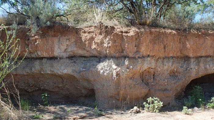
The paper includes an image of the Murray Springs Clovis site in Arizona, and points out that the dark line along the arroyo wall is the black mat that dates to 12,900 years ago. The Murray Springs Clovis Site is 14 miles southwest from Tombstone, Arizona, which is known for its Wild West history. The Younger Dryas Boundary or YDB markers, including magnetic grains and microspherules, iridium, soot, and fullerenes with extraterrestrial helium, are present in the few centimeters just below the black mat at the top of the underlying sediment. This line represents the surface at the end of the Clovis period before the formation of the black mat. Clovis artifacts, a fire pit, and an almost fully articulated skeleton of an adult mammoth were recovered at Murray Springs with the black mat draped over them.
Excavations by Vance Haynes and colleagues also revealed hundreds of mammoth footprints in the sand infilled by black mat sediments. These footprints and the mammoth skeleton appear to have been preserved by rapid burial after the YDB event. No Clovis points or extinct megafaunal remains have been recovered from or above the black mat, indicating that the mammoths and Clovis hunting technology disappeared simultaneously. Vance Haynes submitted an article for publication just one month after Firestone in 2007, but the paper was published only in 2008. The title is intended for experts in archeology. We need to translate it into more understandable language.
The term Younger Dryas refers to a cooling period that started 12,900 years ago and lasted for about 1200 years. The word Rancholabrean is derived from the Rancho La Brea fossil site, which is more commonly known as La Brea Tar Pits in Los Angeles, California. The Rancholabarean termination refers to the time when Pleistocene mammals such as mammoths and saber toothed tigers became extinct at the onset of the Younger Dryas cooling event.
The paper describes 97 archaeological sites, two thirds of which have a black organic-rich layer or black mat in the form of mollic paleosols, aquolls, diatomites, or algal mats with radiocarbon ages suggesting that they are stratigraphic manifestations of the Younger Dryas cooling episode. A mollic paleosol is a dark layer of soil that was formed in a past geological period, an aquoll is a layer of soil formed under wet conditions, diatomites are the fossilized remains of diatoms, which are microalgae, and algal mats are microbial mats that form on the surface of water or rocks. This black mat covers the Clovis-age surface on which the last remnants of the terminal Pleistocene megafauna are recorded.
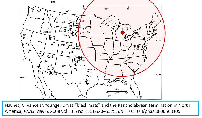
Haynes says that the extinction of the megafauna appears to have been catastrophic, seemingly too sudden and extensive for either human predation or climate change to have been the primary cause. Haynes acknowledges the recent evidence for an extraterrestrial impact, but he does not find it compelling yet. The paper by Haynes has a map of the United States showing 57 locations with black mats of Younger Dryas age represented as filled circles. The open circles are 27 localities with Pleistocene-Holocene transitional sediments but with no black mats. Notice that most of the black mats are in the western part of the United States. Vance Haynes attributes the black mats to relatively moist conditions as a result of higher water tables, indicated by the presence of wet-meadow soils, algal mats and pond sediments. Some black mats do not have enough charcoal to indicate extensive biomass burning. We will come back to this map later.
In 2018, Broughton and Weitzel published a paper titled Population reconstructions for humans and megafauna suggest mixed causes for North American Pleistocene extinctions. These authors are trying to figure out the cause of the megafaunal extinctions. The abstract says: Dozens of large mammals such as mammoth and mastodon disappeared in North America at the end of the Pleistocene with climate change and overkill by human hunters the most widely-argued causes. However, the population dynamics of humans and megafauna preceding extinctions have received little attention even though such information may be telling as we expect increasing human populations to be correlated with megafaunal declines if hunting caused extinctions. No such trends are expected if climate change was the primary cause. We present tests of these hypotheses here by using summed calibrated radiocarbon date distributions to reconstruct population levels of megafauna and humans. The results suggest that the causes for extinctions varied across taxa and by region. In three cases, extinctions appear linked to hunting, while in five others they are consistent with the ecological effects of climate change and in a final case, both hunting and climate change appear responsible.
Broughton and Weitzel only consider climate change and human predation as the causes of the megafaunal extinctions. They do not consider a catastrophic extraterrestrial impact. The paper has a map of the contiguous United States and southern Canada that indicates the frequency of dates by state or province for the directly dated megafauna sample and the distribution of archeological radiocarbon dates from the Canadian Archaeological Radiocarbon Database used in the study.
The absence of megafauna fossils in the southern United States is notable. The states of Arkansas, Louisiana, Mississippi, Alabama, Georgia, South Carolina and North Carolina don't seem to have megafauna fossil evidence at all.
Before examining the maps of the black mats and the megafauna fossils, let us review the Glacier Ice Impact Hypothesis published in 2017, which proposes four mechanisms for the formation of the Carolina Bays. First, a meteorite impact on the Laurentide Ice Sheet ejected glacier ice boulders in ballistic trajectories. The secondary impacts by the ice boulders liquefied unconsolidated ground. Oblique impacts of ice boulders on liquefied ground created inclined conical cavities, and viscous relaxation reduced the depth of the conical cavities to produce shallow elliptical bays. Michael Davias proposed that Saginaw Bay is the convergence point of the Carolina Bays and the Nebraska Rainwater Basins. These impact structures only occur within a radius of 1500 kilometers from Saginaw Bay, which was the range of ballistic sedimentation of the ejecta curtain.
When we draw a circle with a radius of 1500 kilometers from Saginaw Bay, which was proposed as the location from where the glacier ice boulders were ejected by an extraterrestrial impact, we notice that the black mats are found mostly beyond the 1500 kilometer radius, away from where the secondary glacier ice bombardment occurred. This image combines the black mat map by Haynes and the megafauna fossil map by Broughton and Weitzel. The circle marks the 1500 kilometer radius from Saginaw Bay.
Let us take a look at the Carolina Bays in South Carolina. A recent video calculated the energy of the impacts that created the Carolina Bays in Marlboro County, South Carolina. The detailed analysis of the overlapping impacts indicated that Marlboro County, South Carolina received a glacier ice bombardment with energy of 7.95 megatons of TNT per square kilometer. That is about 8 megatons per square kilometer.
With this tremendous glacier ice bombardment, all the megafauna like the mammoths, short-faced bears, giant armadillos and all the forest plants would have been completely obliterated and there would be no remains to be fossilized. Another recent video calculated the energy of emplacement of the smaller Carolina Bays that are found in New Jersey as 880 kilotons per square kilometer.
The density of the Carolina Bays enable us to deduce the distribution of the ejecta from the extraterrestrial impact. The bays in Marlboro County, South Carolina are large and overlapping. They correspond to a kinetic energy of almost 8 megatons of TNT per square kilometer. That is enough to grind up megafauna into a paste that leaves nothing to fossilize. In New Jersey, the bays are small and correspond to a kinetic energy of 880 kilotons of TNT per square kilometer. That is enough to kill all the megafauna, but not enough to completely pulverize them, so some bones remain to be fossilized.
The megafauna extinction map also tells us something about the ejecta curtain. The lack of fossils in Arkansas, Louisiana, Mississippi, and Alabama indicates that the impacts of the glacier ice were just as powerful in these states as in South Carolina, but these states have no Carolina Bays because the ground is hard and could not be liquefied to allow the formation of inclined conical cavities. The impacts on hard ground shattered the ice projectiles and pulverized the megafauna, but they did not leave the geological evidence that we find in the Atlantic Coastal Plain. It is interesting to see that archeology and geology complement each other to provide a more complete story of the Earth's recent past.
12,900 years ago, an extraterrestrial impact on the Laurentide Ice Sheet ejected pieces of ice in ballistic trajectories. The secondary impacts on unconsolidated ground created the Carolina Bays and the Nebraska Rainwater Basins. The impacts on hard ground created shards of ice and thick clouds of ice particles. Nuclear explosions can provide an analogy of what happened when the ejecta curtain collapsed.
On July 6, 1962, an atomic blast in Nevada with energy of 104 kilotons of TNT exploded upward and outward displacing more than eleven million tons of soil. A circular area of the desert floor five miles or 8 kilometers across was obscured by fast-expanding dust clouds moving out horizontally from the blast site like a pyroclastic surge. This image shows the start of the expansion of the low-hanging dust cloud far beyond the area covered by the ejecta.
Similar surface dynamics may have been responsible for the black mats. within the circle of ballistic sedimentation, the vegetation was ground up and worked into the soil, so there was no vegetation on the surface to create a black mat. Beyond the ballistic sedimentation circle, the air pressure of the falling ice projectiles blew a cloud of ice particles that covered grasses and trees like an avalanche. The thick coating of ice smothered the vegetation and created the moist conditions that promoted growth of algae to form the black mats.
Before concluding the topic of the black mat, I want to point out that the black mat is at a very shallow depth from the modern surface. In this picture, we can estimate that the black mat is about 2 feet or about 60 centimeters below the surface. One of the reasons why the Carolina Bays have been assumed to have originated by wind and water processes is because the dates obtained for the bays by Optically Stimulated Luminescence or OSL have a range spanning thousands of years that would make it impossible for all the bays to have been created contemporaneously. However, the samples for OSL have to be taken more than one meter below the land surface to minimize cosmogenic dose errors, but this requirement may result in obtaining samples that are far deeper than the surface of 12,900 years ago. This will cause the OSL dates to correspond to very old terrain, and not to the time of bay formation.
